Precision Agriculture Services: What a Drone Operator Actually Sees in the Field
Flying Over the Farm, Not Around It
The first time I flew an agricultural drone over a 200-acre winter wheat field, I expected to see a uniform green carpet. What I actually saw was a patchwork: dark stripes where the drill had doubled up, pale circles where the previous crop had drained the soil, and a long yellow smear along the headland where the spreader had been running too fast. That flight changed how I think about precision agriculture services. It is not about having a fancy gadget. It is about seeing the field the way it actually is, then acting on what you find.
Most farmers already know their fields better than anyone. They have walked them, worked them, and watched them dry out or flood in the same spots year after year. But walking gives you a ground-level view of a few plants. A drone gives you a field-level view of thousands. That difference matters when you are trying to decide where to spend your agronomy budget and where to save it.
The Tools Behind the Picture
Precision agriculture services have grown up around a set of tools that work together. Agricultural drones are the visible part, but the real magic happens when you combine them with the data from soil sensors, yield mapping, and GPS guidance. Each tool fills a gap the others cannot.
Soil sensors, for example, tell you about the ground before you even plant. They measure moisture, temperature, and sometimes nutrient levels at different depths. Yield mapping tells you what actually happened at harvest, down to a few square metres. Put those two layers together with a drone image from mid-season, and you start to see patterns that explain why some parts of the field always underperform. Maybe it is a compaction layer. Maybe it is a drainage issue. Maybe the seed rate was wrong for that particular soil type.
The drone adds the time dimension. You can fly a field every week if you need to, and the cost is small compared to the value of catching a problem early. NDVI imagery, which measures the health of the crop by its light reflectance, has been around for decades. What has changed is how cheap and easy it is to get. You do not need a satellite pass or a plane. You can launch a DJI Agras or a similar platform from the farmyard and have an NDVI map on your tablet before the morning coffee goes cold.
From Map to Action: Variable Rate Application
The map is only the beginning. The real payoff comes when you turn that map into action, and that is where variable rate application enters the picture. Instead of putting the same rate of granular fertiliser across the whole field, you adjust the rate on the go, based on the zones you have identified.
I remember a farm in Norfolk where the yield map showed a clear low patch in the middle of the field, right over an old river channel. The farmer had been applying extra nitrogen there for years, trying to push it up, but it never worked. The soil sensors showed why: the ground was waterlogged for most of the spring, so the roots never got deep enough to use the fertiliser. The answer was not more nitrogen. It was better drainage and a different seed rate. That kind of insight comes from combining data, not from a single flight.
Variable rate application also changes the economics of spreading. When you can match the seed coating or the agrochemical dose to the actual need, you stop wasting product on areas that do not respond. That saves money, but it also reduces the risk of leaching and runoff. In a wet year, that can be the difference between a clean watercourse and an expensive conversation with the Environment Agency.
Drones in the Spreading and Spraying Work
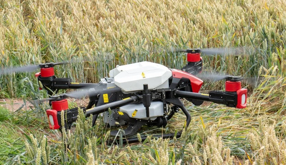
When people hear about agricultural drones, they usually think of crop scouting or imaging. But the bigger change is happening in the spreading and spraying itself. Drones like the DJI Agras are not just cameras with rotors. They are working machines that can carry tanks and hoppers, fly low over the crop, and apply products with a precision that ground equipment often cannot match.
Consider the problem of applying a herbicide to a crop that is too wet to drive on. A tractor will rut the ground, compact the soil, and damage the crop. A drone flies over it. The same goes for a late-season fungicide when the crop is too tall for a tractor boom. The drone can work at a height that keeps the spray on the target and off the neighbouring hedgerow. It is not about replacing the tractor. It is about doing the jobs that the tractor does poorly, or not at all.
There is also a practical advantage in small or awkward fields. A lot of UK farms have fields that are not square, not big, or not accessible. Setting up a full-size sprayer for a two-acre strip is a waste of time and horsepower. A drone can be ready in minutes. That flexibility is what makes precision agriculture services attractive to smaller enterprises as well as broadacre farming operations.
What the Tech Does Not Solve
It would be easy to paint a picture of perfect fields and unlimited yields, but that is not how it works. The technology is only as good as the decisions you make with it. A drone can show you a problem, but it cannot tell you whether to fix it with more water, more nitrogen, or a different variety. That still takes agronomy, experience, and judgment.
There are also practical limits. Battery life is better than it used to be, but a drone still only covers so many acres in a day. Weather matters. High winds and rain stop flights, and in the UK you can lose a whole week to a front coming through. The data also needs to be processed and interpreted. An NDVI map is just a coloured picture until someone who understands the crop reads it correctly. That is where a good agronomist earns their keep, and where the value of a service provider really shows.
Making It Work on Your Farm
If you are thinking about bringing precision agriculture services into your own operation, start small. Pick one field that you know has a problem, and fly it a few times through the season. Compare what you see with the yield map from the last harvest. See if the story matches.
You also need to think about how the data fits your existing kit. If your farm already runs on John Deere equipment, their system might integrate the drone data into your existing GPS guidance and variable rate controller. If you are not that digital yet, you can still use the maps to write a manual prescription for the spreader operator. There is no rule that says you have to automate everything at once.
One thing to watch is the temptation to buy a drone and do it all yourself. The learning curve is steeper than it looks. You need to understand the flight planning, the data processing, and the regulations. You also need to know what to do with the output. A lot of farmers find that hiring a specialist for a few targeted jobs is cheaper and less stressful than buying the kit and the training themselves. That is the argument for a service, rather than a machine purchase.
The Practical Side of Precision
Let me give you a concrete example from a farm I worked with in Cambridgeshire. They had a field of oilseed rape that was struggling in patches. The crop scouting with a drone showed the problem was not disease or pests. It was a variable soil depth, with patches of gravel where the bedrock was close to the surface. The NDVI map made that clear. The yield map from the previous crop confirmed it.
We sat down with the agronomist and decided to change the seed rate for the next season, and to use variable rate application for the granular fertiliser. The areas over the gravel got less nitrogen, because the crop could not use it anyway. The deeper soils got a bit more. The result was a more even crop, and a lower total fertiliser bill. It was not a dramatic transformation. It was just a better match between inputs and the ground.
That is what precision agriculture comes down to. It is not about chasing the latest gadget. It is about using data to make better decisions, and using tools like agricultural drones to act on those decisions at the right time and the right place. The phrase "precision agriculture services" gets thrown around a lot, but in practice it means a cycle: observe, interpret, act, and check the result.
Where the Industry Is Heading
The next few years will bring more integration. Drones will talk to tractors, and tractors will talk to the office. Seed coating and agrochemical products are being developed that respond to variable rates more effectively. The spreader equipment on the ground is getting smarter, too, with real-time sensors that adjust the flow as the machine moves across the field.
For the farmer, the question is not whether to adopt these tools, but how fast. The early adopters are already seeing the benefit in farm efficiency. The laggards will catch up when the pressure on margins forces them to look at the data. The good news is that you do not have to go all in. You can test the waters with a single field, a single season, and a single service provider.
At the end of the day, precision agriculture services are a means to an end. The end is a healthier crop, a lower input bill, and a better bottom line. The means are the drones, the sensors, the maps, and the software. But the most important part is still the person who looks at the data and decides what to do next. That has not changed since the first farmer walked a field, and it will not change just because the view is now from above.